3 New Features
March 31, 2020 by Jordan
Three New Map Assets
With so many of us working from home, we recently set aside the time to create a few, new features to (hopefully) keep you productive.
So next time you login – consider checking these out:
- Recreational Trails. Found under the Transportation Layer. Hiking, biking, equestrian trails, you name it – they’re probably being used hard right now. It’s something that can easily be mapped today – and serve as a valuable planning tool in the future.
- Curbs. Also found under the Transportation Layer – start tracking the location, type, material, and condition of this often overlooked infrastructure item.
- Sanitary Sewer Laterals. Dig up those old as-built drawings, hand sketches or PAONECALL memories. They can be tedious to draw, but it’s incredibly helpful to have them located. And if you’ve previously mapped your laterals in CSDatum – we’ve already split them apart from the main lines.
I realize one or two might not be applicable to you – but they should all be easy to map (via aerial imagery), and easy to understand.
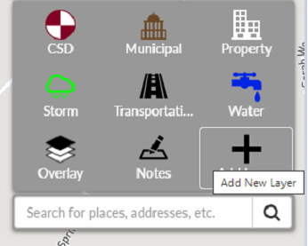
And remember – until you add a Layer or Asset for the first time, it won’t be visible in your Map Legend or Menu. We did this to minimize your screen clutter, so click on ‘Add New Layer’ or ‘Add New Asset’ to see all of the available options.
This also seems like a good time to mention other (existing) assets that are easily mapped – especially if you’re connected to your office network.
- Municipal Layer -> Land Development. Draw the polygon of the original tract of land and attach a PDF of the recorded plan.
- Property Layer -> Parks, Trees, Buildings.
- Transportation Layer -> Parking Lots, Bridges, Traffic Signals, Sidewalks and Curb Ramps.
- Notes Layer. We’ve recently added more color options to this flexible layer – use it to map sinkhole occurrences, landscaping needs, pavement markings, guide rail, future projects, you name it.
- Inspection Templates. This is a great time to build or revise your various inspection forms. So when you or your coworkers are all back out in the field, you’re capturing the right information with relative ease.
If you’ve already mapped some these items in GIS, and would like them added, please send the files over for a quick import – we’re here to help!
Lastly, if can’t remember your username/password - please go here.